

“Not everything that is faced can be changed, but nothing can be changed until it is faced.” – James Baldwin
When you hear the word segregation, what do you think of? Many of us think back to the Jim Crow era and the Civil Rights Movement when you could find “Whites only” signs for restaurants, bathrooms, water fountains and more. Yet, American cities continue to be highly segregated. Using U.S. Census Bureau data, Governing Magazine found that Detroit ranks as the fourth-most segregated metro area in the nation, and Michigan cities such as Grand Rapids and Battle Creek have a high rate of segregation in housing.
Present-day policies and practices are built on a long history of racially distributed resources and ideas that shape our view of others and ourselves. While the explicit policies or actions may no longer be in place, their legacy can be seen in where roads were built, which communities had access to home ownership, and where companies built their plants. Historical policies that continue to shape and enforce segregation today include:
- Redlining (the practice of denying people access to credit because of where they live)
- Predatory lending
- Forced displacement of Indigenous people
- Educational segregation of Black, Indigenous, and Hispanic students
- Excluding Black veterans from the G.I. Bill
- Forced segregation of neighborhoods by the Federal Housing Authority.
While each of these policies operated in their own ways, they shared some common traits. They enforced unequal resource distribution – spaces and opportunities for White people were consistently more resourced; and, if they eventually were integrated, White institutions remained. Inequities persist in employment, housing, education, healthcare, government and other sectors.
Let’s take a closer look at one example that can still be felt and seen in communities across the United States. “Residential Security” maps like the example shown of Kalamazoo below were created by the Home Owners’ Loan Corporation (HOLC) beginning in the 1930s for cities across the US. These maps highlight how loan officers, appraisers and real estate professionals evaluated “mortgage risk”, which was then used to carry out lending practices for much of the 20th century. Data on racial and ethnic identity along with class of residents was included in the data collected. Neighborhoods were then color-coded on maps: green for the “Best” – White, mostly middle-class neighborhoods, deemed most deserving of home ownership; blue for “Still Desirable”; yellow for “Definitely Declining” – usually used to identify white immigrant neighborhoods; and red for “Hazardous” – used for African American communities (Michigan State University).
Even if African American families would have qualified for loans (income, savings, ability to repay the loan), they would have been denied a mortgage in a red-coded neighborhood. Simultaneously, the Federal Housing Administration supported developers to build into home deeds racially restrictive covenants that prohibited the sale of homes to non-Whites. These agreements were often enforced by Homeowner’s Associations to ensure that neighborhoods remained exclusively White.
Consider that a child’s wealth potential is strongly related to their parents’ wealth and that for most families, a home is the primary way they store and build wealth. The policies of nearly 100 years ago are only 1-2 generations removed from us. If your grandparents were legally and systematically denied the opportunity to buy a house, what might be the impact of that policy today?
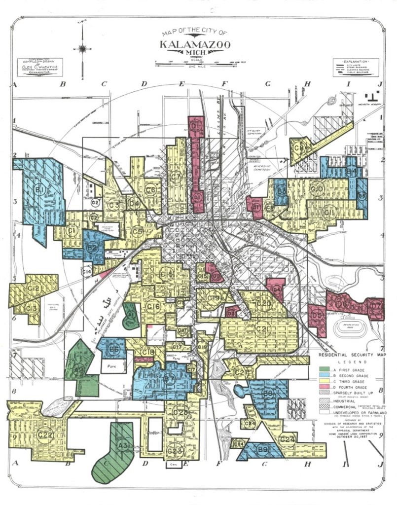
Image description: title text reads, ”Map of the City of Kalamazoo, Mich.” Below the title is a hand-drafted map coded by color with red, yellow, blue, and green –shaded segments. Kalamazoo’s red shaded segments are primarily concentrated to the north and east. A key in the lower right reads, ”residential security map” with the following: Green: First Grade; Blue: Second Grade; Yellow: Third Grade; Red: Fourth Grade; Grey with dot pattern: Sparsely Built; Grey with stripes: Industrial; Grey checkered: Commercial; and, White: Undeveloped.”
Today’s Challenge
Read
Learn more about the history of Redlining in Lansing Redlining, I-496, and Lansing’s African-American Community. (4 mins) https://cedamichigan.org/2019/04/redlining-in-lansing/
Learn more about the history and legacy of redlining in Michigan Redlining in Michigan: The History and Legacy of racist Housing Policies, by Craig Wesley Carpenter, PhD (MSU). (4 mins)
https://www.canr.msu.edu/redlining/ Take a deeper look into how Home Owner’s Associations impact community neighborhoods: How HOAs can shape neighborhoods (Urban Institute). (6 mins)
https://housingmatters.urban.org/articles/how-hoas-can-shape-neighborhoods
Watch
Why are cities still so segregated? NPR’s Code Switch looks at the factors contributing to modern day segregation. (Note: Includes explicit language in first 15 seconds) (6:36) https://www.youtube.com/watch?v=O5FBJyqfoLM
Paving the Way, about the transformation the construction of I-496 had on Lansing and its people when it was completed in 1970. (6 mins) https://www.youtube.com/watch?v=Ndb2JJGqoSE
How FDR Segregated Kalamazoo by Kalamazoo Public Library’s Matt Smith about the history of redlining, racially restrictive covenants, and segregation in Kalamazoo – and how this history lives on in our region’s housing policies today. (1:33:37) https://www.kpl.gov/video/how-fdr-segregated-kalamazoo/
Discuss
What information from today’s topicstood out to you the most? How does it help you understand your community and/or the people who live in your community?